Trail of the Week: Devils Causeway


Shelby Reardon
YAMPA — There’s one obvious reason why Devils Causeway is such a popular hike: it’s awesome. The final stretch of the hike is rough, but the view is more than worth it, and the experience of standing in the middle of the causeway is exhilarating.
Of course, with a hike as well-known and accessible as the causeway, it’s near impossible to get the trail to yourself. That’s why, when my hiking partner and I reached the skinny bridge of boulders, we were shocked we had it to ourselves. There were tons of people on the trail, and a few coming up behind us, so we each took a few minutes to take in the sights, then let the next group take over.
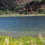
Devils Causeway has it all. It starts along the shores of Stillwater Reservoir with views of the Flat Tops Wilderness Area. Eventually, the trail splits. To access the causeway, veer right. The trail takes hikers through a small section of forest before opening up to a small Alpine lake, Little Causeway Lake. From there, the real hiking begins. The incline starts casually, but soon, the switchbacks are in sight.
I was proud of how I powered through those switchbacks and was relieved to get to the top. We were greeted by a sheet of wildflowers and laughed at by another incline. The last section before the causeway is the worst, but it’s short. Before you know it, you’re on top of the world, standing on top of a plateau at 11,800-ish feet. Just ahead, the massive plateaus that are the Flat Tops appear to have been pinched. On either side is a straight drop, followed by steep slopes falling hundreds of feet down before flattening out.
If the weather holds out and you’re feeling a longer hike, continue past the causeway and complete the 10-plus mile loop. The rest of the loop is a breeze compared to the climb to the causeway.
Out and back to the causeway is about 6 miles and 1,500 feet of elevation gain.
Getting there is easy. Take U.S. Highway 40 to Yampa, which is about 40 minutes south of Steamboat. Then, take Routt County Road 7 all the way to the end until it turns into Forest Service Road 900. All the way at the end of that is the trailhead.

Shelby Reardon
If I’m being honest, the highlight of the hike was a Saint Bernard named Grizz. The humans he was hiking with weren’t confident that his goofy big paws could handle the causeway, which in places, requires careful stepping. So, while they crossed the causeway, I got to hold on to Grizz. He was such a good boy.
If you’re itching for a beer, ice cream or snack after a day in the Flat Tops Wilderness Area, I recommend stopping by The Antlers Cafe & Bar or Montgomery’s General Store.
To reach Shelby Reardon, call 970-871-4253, email sreardon@SteamboatPilot.com or follow her on Twitter @ByShelbyReardon.


Support Local Journalism
Support Local Journalism
Readers around Steamboat and Routt County make the Steamboat Pilot & Today’s work possible. Your financial contribution supports our efforts to deliver quality, locally relevant journalism.
Now more than ever, your support is critical to help us keep our community informed about the evolving coronavirus pandemic and the impact it is having locally. Every contribution, however large or small, will make a difference.
Each donation will be used exclusively for the development and creation of increased news coverage.