Historical marker roundup
OK, we know road trips can get a tad boring. So spice yours up by stopping at historical markers surrounding Steamboat. One of the oldest such programs in the nation, Colorado’s commemorations date back to the Daughters of the American Revolution in 1907. Produced by the Colorado Historical Society and government transportation departments, these signs herald Colorado’s people, events and issues, helping you journey through the past while providing an excuse to stretch your legs. Following are a handful to to look for within a few hours of town.
Hayden Rest Area
Location: Hayden Rest Area, Mile marker 100.5 (7 miles northwest of Hayden, U.S. Highway 40)
Topic: King Coal/Taylor Grazing Act/Farrington Carpenter/Hayden Surveys
Year installed: 1965-1997
This four-panel marker calls attention to mining, grazing, surveyors and more, championing coal as the region’s king of minerals. While large-scale mining awaited the coming of the railroad in 1908, today, of Colorado’s eight major coal regions, 13 mines in Routt and Moffat counties account for over half of the state’s total coal production. Other panels tout the Taylor Grazing Act and the region’s competition for free range land, resulting in the creation of the Taylor Grazing Act in 1934, as well as maverick rancher Farrington Carpenter, appointed by President Franklin D. Roosevelt as the government’s first director of the Division of Grazing. A district attorney known for prosecuting cattle rustlers and negotiating a cease-fire between sheepmen and cattlemen, Carpenter is the namesake for The Nature Conservancy’s Carpenter Ranch. The final panel heralds geologist Ferdinand V. Hayden’s famous Hayden Surveys, which produced Colorado maps between 1859 and 1876.
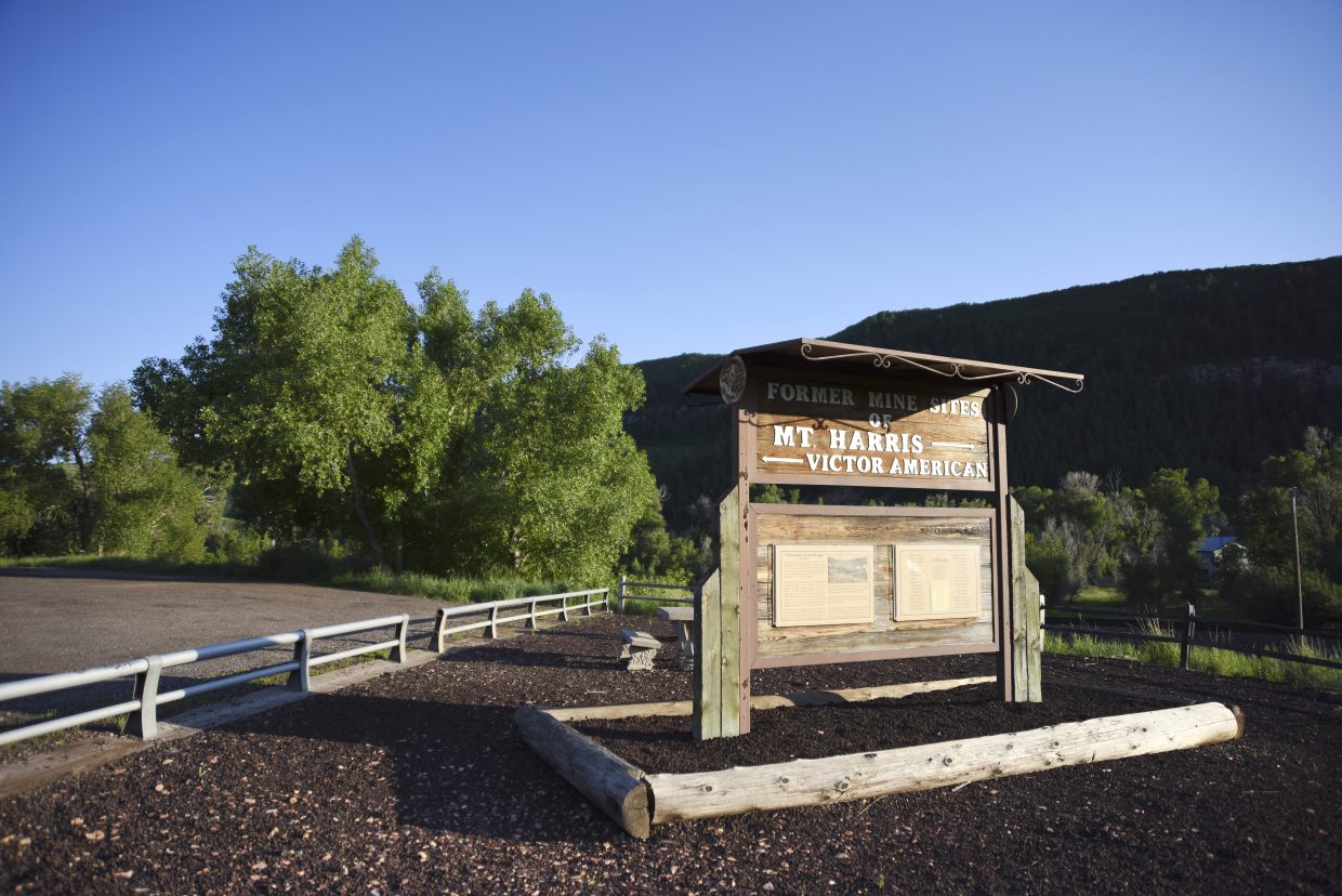
Mount Harris
Location: Mile marker 114.5, U.S. Highway 40
Topic: The ghost town of Mount Harris
Year installed: 1990
This marker stands at the former townsite of Mount Harris between Milner and Hayden, a community settled in 1914 when brothers George and Byron Harris opened the first mine at Bear River Canyon. With a conveyor carrying coal across the Yampa River to waiting railroad cars, the town was a hub of activity for three additional mining camps, and by 1916, it was a nationally recognized model company town, sporting company offices, a general store, post office, drug store, barbershop and pool hall. Main Street also was home to three boarding houses, the Colburn Hotel, a church, doctor offices and a community center for meetings, Saturday night dances and movies. By 1920, Mount Harris was the largest town in the county with 1,295 residents. On a sad note, one of Colorado’s worst mining disasters occurred there in 1942 when a methane gas explosion killed 34 miners. With the rise of petroleum dampening coal demand, the Victor American Camp shut down in the early 1950s, and in 1958, the Mount Harris mine closed.
Oak Creek
Location: Mile marker 56.5, Town Park, Oak Creek
Topic: Coal/Labor Day
Year installed: 1999
Featuring photos of mines, parades and even the arrival of the National Guard in 1913 to settle a labor dispute, this two-panel marker commemorates coal, Labor Day and a town founded in 1908 to feed the locomotives of the Denver, Northwestern & Pacific Railroad. At one point, nearly two dozen languages were spoken in Oak Creek, and a local mine featured the state’s largest hoist at 280 tons. The community staged its first Labor Day celebration in 1915, a year after a landmark United Mine Workers strike. The event let miners protest labor injustices and renew common bonds. Today, Oak Creek’s Labor Day party is one of Colorado’s largest, featuring parades, contests and the crowning of the annual Coal Queen.
Dinosaur
Location: Dinosaur (U.S. Highway 40)
Topic: Echo Park Dam/Ancient Inhabitants/Rangely Oil Field
Year installed: 1997
Conservation, natives and oil are the theme of this four-panel marker, which pays tribute to the oilmen who first tapped the Rangely Field in 1902 — the boomtown of Artesia, later renamed to its modern-day Dinosaur; the Fremont Indians, who lived in the area from 200 to 1200 A.D.; and the defeat of the controversial Echo Park Dam in Dinosaur National Monument in 1958, thanks to opposition by the Sierra Club. It also serves as the official welcome plaque for travelers entering Colorado from Utah.
Maybell
Location: Town Park (north side of U.S. Highway 40)
Topic: Ranching/Rustlers/Fort Davy Crockett/Jim Beckwourth
Year installed: 1997
This four-panel marker highlights the area’s ranching and renegades. The first panel depicts Brown’s Hole and Robber’s Roost and the history of such outlaws as Butch Cassidy and his Wild Bunch, Isom Dart and Black Jack Ketchum. The panel also highlights tough-as-nails pioneer Elizabeth Bassett and her two daughters, Ann “Queen of the Cattle Rustlers,” and Josie. Panel two honors the region’s fur trappers, as well as Fort Davy Crockett, built along the Green River after Crockett’s death at the Alamo in 1836, and such luminaries as Kit Carson, Joe Meek and ex-slave captain Jim Beckwourth, who enjoyed a 40-year career as a trapper, scout and backwoodsman. Panel three showcases early ranching families, including crusty Charley Crouse, the Hoy brothers, the Spicers and the Bassetts who routinely faced down rustlers, Utes, bandits and more. The final marker pays homage to the region’s infamous Sheep-Cattle Wars, which pitted sheepherders against cattlemen and resulted in the Taylor Grazing Act of 1934.
Jackson County
Location: Mile marker 57.9 on Colorado Highway 125, Wyoming border north of Walden
Topic: North Park/Walden/Wildlife
Year installed: 2002
This marker highlights the history of Walden and North Park, which the Utes called the “Bull Pen” for its bison. It also brings attention to the area’s ample beaver, hunted by the likes of Kit Carson. Unsettled until a brief silver rush in the 1870s spawned the town of Teller City, the area later hosted residents who stayed on to raise cattle, cut timber or mine coal. Founded in 1889 by refugees from the Teller City mining bust, Walden was the only incorporated town in North Park and a vital link to the world beyond the basin. Its first railroad came in 1891 to serve the nearby Coalmont coal mine, at the time one of the largest strip mines in the world. The marker also champions the area’s wildlife, thanks to its variety of habitat and spring runoff ensuring ample water and vegetation for antelope, deer, elk, black bear, moose, beaver and waterfowl.
Grand County
Location: Winter Park, Hideaway Town Park
Topic: Skiing/Moffat Road/Berthoud Pass
Year Installed: 1997
This panel pays homage to Norwegians Carl Howelsen and Angell Schmidt, who traveled through Middle Park in 1911 and entertained onlookers at Hot Sulphur Springs with their ski jumping. It also commemorates the Denver, Northwestern & Pacific Railroad, which topped 11,660-foot Rollins Pass in 1905; the history of Berthoud Pass, whose road was built with the help of mountain man Jim Bridger; and the opening of the 6.2-mile Moffat Tunnel in 1928, which brought skiers to the area and led to the opening of Winter Park in 1940.
Kremmling
Location: Inspiration Point (8.5 miles south of Kremmling on Colo. Highway 9)
Topic: Moffat Road/Argo Squirrels/Mountain Exploration/Geology
Year installed: 1997
This marker heralds the Moffat Road, brainchild of banker and railroad entrepreneur David Moffat; the famous “Argos Squirrels,” immigrant surveyors who scaled the cliffs of Gore Canyon and hung from swinging bridges to build the railroad through the canyon; and Anglo-Irish baronet Sir St. George Gore, who explored the region in 1854, guided by mountain man Jim Bridger.
Location: Downtown Kremmling (U.S. Highway 40)
Topic: Kremmling/Ranching/Dr. Ceriani
Year installed: 2003
This marker details the history of Kremmling, founded in 1884 by Rudolph Kremmling, who built a dry-goods store to serve local ranchers. It also touches upon Middle Park ranching, which by the mid-20th century was known nationwide for its prize-winning Herefords (local Fred DeBerard was named “Stockman of the Century” in 1951). It also honors 1912’s Bar Lazy J Guest Ranch, still the oldest guest ranch in Colorado, as well as early doctors like Dr. Susan Anderson (“Doc Susie”), Dr. Archer Sudan and Dr. Ernest Ceriani, who was featured in a 1948 Life magazine article and retired in 1986 after 40 years of service.
Meeker
Location: Meeker (mile marker 72.6 at Colo. Highway 64 & Road 7)
Topic: Attack at White River/Battle of Milk Creek
Year installed: 1997
This marker calls attention to U.S. Indian agent Nathan C. Meeker, who, in 1879, wanted the Utes to become Christians and farmers and plowed up the tribe’s sacred horse track. When they objected and responded by killing Meeker and 11 other white men, 120 troopers under the command of Major Thomas Thornburgh crossed Milk Creek 15 miles north, the northern boundary of the Ute Reservation. The Battle of Milk Creek ensued, with the U.S. troops joined by the 9th Cavalry (the famed African-American “Buffalo Soldiers”) and 5th Cavalry. By the battle’s end, 23 Utes were killed, as well as Thornburgh and 10 other U.S. soldiers. It was the Utes’ last military stand against white encroachment. Two years later, the Tabeguache and White River Utes were relocated to barren reservations.
Rangely
Location: Downtown Rangely, Colorado Highway 64
Topic: Escalante Expedition
Year installed: 1951
This marker commemorates the 1776 Dominguez-Escalante Expedition, which passed through the region in its attempt to find an overland route from Santa Fe, New Mexico, to a Catholic mission in Monterey, California. Led by Franciscan priests Francisco Atanasio Domínguez and Silvestre Vélez de Escalante and cartographer Don Bernardo Miera, eight men traveled through present day western Colorado to the Utah Valley in Utah, aided by three Timpanog Ute guides. While their route became part of the Old Spanish Trail, the group ended up aborting its mission and returning to Santa Fe through Arizona.
Support Local Journalism
Support Local Journalism
Readers around Steamboat and Routt County make the Steamboat Pilot & Today’s work possible. Your financial contribution supports our efforts to deliver quality, locally relevant journalism.
Now more than ever, your support is critical to help us keep our community informed about the evolving coronavirus pandemic and the impact it is having locally. Every contribution, however large or small, will make a difference.
Each donation will be used exclusively for the development and creation of increased news coverage.