Historic El Niño could mean a wetter start to Colorado’s winter — but the above-average snow might not stick around
Seasonal outlooks published in September show the Western Slope could be on track for above-average precipitation to kick off the winter season

Austin Colbert/The Aspen Times
Editor’s note: This story has been updated to correct an error in the conversion of the sea surface temperature anomaly from Celsius to Fahrenheit.
El Niño patterns are approaching record-setting levels, raising the possibility of an unusual winter on Colorado’s Western Slope.
El Niño conditions — characterized by above-average sea surface temperatures across the central to eastern equatorial Pacific Ocean — officially arrived in June, with the U.S. National Oceanic and Atmospheric Administration noting that it could intensify into a “strong” or “super” El Niño by the end of the year.
A new winter outlook shows El Niño has intensified in the Northern Hemisphere, increasing the chances of a “very strong” fall and winter El Niño to more than 90%. If conditions continue to strengthen throughout the winter — with a likely peak between November and December — the super El Niño could break historical records going back to at least the 1950s.
For Colorado, this could mean stronger snowfall early in the winter season. Outlooks predict the Western Slope might not hold on to this pattern for long, however.
Over the past month, sea surface temperature anomalies have exceeded 3 degrees Celsius — or a change of 5.4 degrees Fahrenheit — in the eastern equatorial Pacific, according to data from NOAA. Historically, a very strong or super El Niño has been characterized by a temperature anomaly of 2 degrees Celsius or higher.
With multiple prediction models showing El Niño is expected to strengthen through the end of the year, the Climate Prediction Center predicts a 75% chance of a historic event during the October-December season.
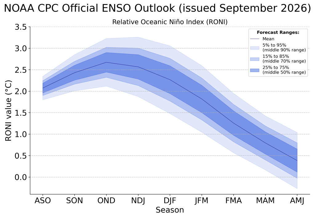
“With an event of this magnitude, the chances of experiencing impacts consistent with El Niño are larger, though not guaranteed,” NOAA reported in a Sept. 10 post.
Western Slope could see a cooler, but drier, winter
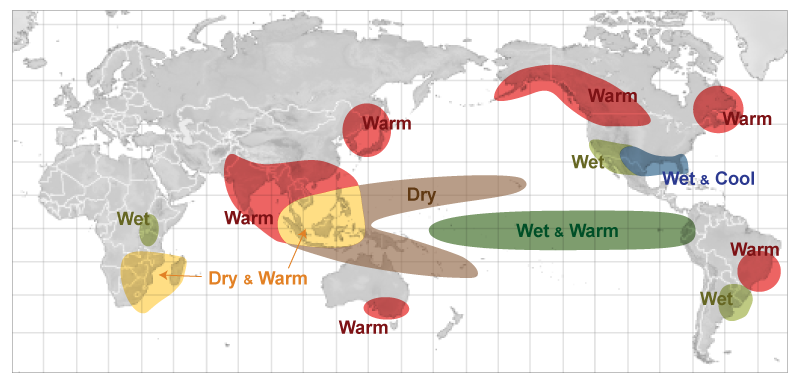
In Colorado, El Niño conditions have historically translated to strong precipitation early in the fall and winter season followed by below-average snowfall during the middle of the season, according to OpenSnow Meteorologist Alan Smith. So far, winter outlooks suggest the Western Slope might see a similar pattern.
In June, seasonal precipitation outlooks showed the Western Slope receiving above-average rainfall from July through September — heavily influenced by El Niño conditions. Seasonal outlooks also showed Colorado leaning toward a 45-50% chance of above-normal temperatures, which came through fruition in the form of Colorado’s hottest summer on record.
Now, official three-month outlooks from NOAA suggest Colorado could escape the heat enveloping the rest of the country.
From October through December 2026, Colorado has equal chances of experiencing above- or below-normal temperatures, making it one of seven states to escape a hotter-than-normal forecast. Updated outlooks published Sept. 17 show the state could hold on to these equal chances into the spring.
All parts of the state are also expected to receive above-average precipitation from October through December, with southeastern counties seeing up to a 50% chance of above-average precipitation. OpenSnow’s fall weather outlook suggests this could bring earlier-than-normal snowfall to parts of the High Country.
Could precipitation slow down mid-winter?
While the Western Slope is included in the forecast for above-average precipitation during the first months of winter, further outlooks show the region could be left out of some of the state’s precipitation later in the season.
The November-January outlook shows the Western Slope has equal chances of experiencing above- or below-normal precipitation, while the eastern half of the state remains with at least a 33-40% chance of seeing more snow than normal.
A strong El Niño doesn’t mean these predictions are guaranteed to stick, however. Modern U.S. records include only three “super” El Niños: 1982-83, 1997-98 and 2015-16. While the first delivered significant snowfall to Colorado, the other two saw close to average conditions, according to analysis by the Colorado Climate Center.
“Drawing firm conclusions from three events is unreliable, and our physical understanding of Earth’s climate system offers no clear threshold where impacts suddenly scale,” wrote Peter Goble, assistant state climatologist at the Colorado Climate Center, in a Sept. 3 report. “On the positive side, dynamical seasonal climate models and the Climate Prediction Center both indicate elevated odds of above-normal precipitation across most of Colorado through spring.”
Climate change also complicates what Colorado can expect from a strong El Niño, Goble wrote, adding that “Colorado is warming, and average precipitation is likely decreasing in western Colorado.”
Even if El Niño conditions lead to more storms, chances are lower that the precipitation will fall as snow at lower elevations.
“Colorado continues to suffer from severe drought largely driven by snowpack deficits last winter and record warm temperatures. There is a strong appetite among people for moisture. The brewing super El Niño may offer some hope, but a wide array of outcomes are possible this winter,” he wrote. “It is a bit like playing a game of poker with a few extra aces and kings in the deck. The deck may be stacked in our favor, but we could still draw a crummy hand.”

Support Local Journalism
Support Local Journalism
Readers around Steamboat and Routt County make the Steamboat Pilot & Today’s work possible. Your financial contribution supports our efforts to deliver quality, locally relevant journalism.
Now more than ever, your support is critical to help us keep our community informed about the evolving coronavirus pandemic and the impact it is having locally. Every contribution, however large or small, will make a difference.
Each donation will be used exclusively for the development and creation of increased news coverage.